Location
Located 14 km northwest of Merritt and 190 km northeast of Vancouver, the New Craigmont property is easily accessed via paved roads from Vancouver, Kamloops, and Kelowna, and is serviced by hydroelectric power (Fig 1).

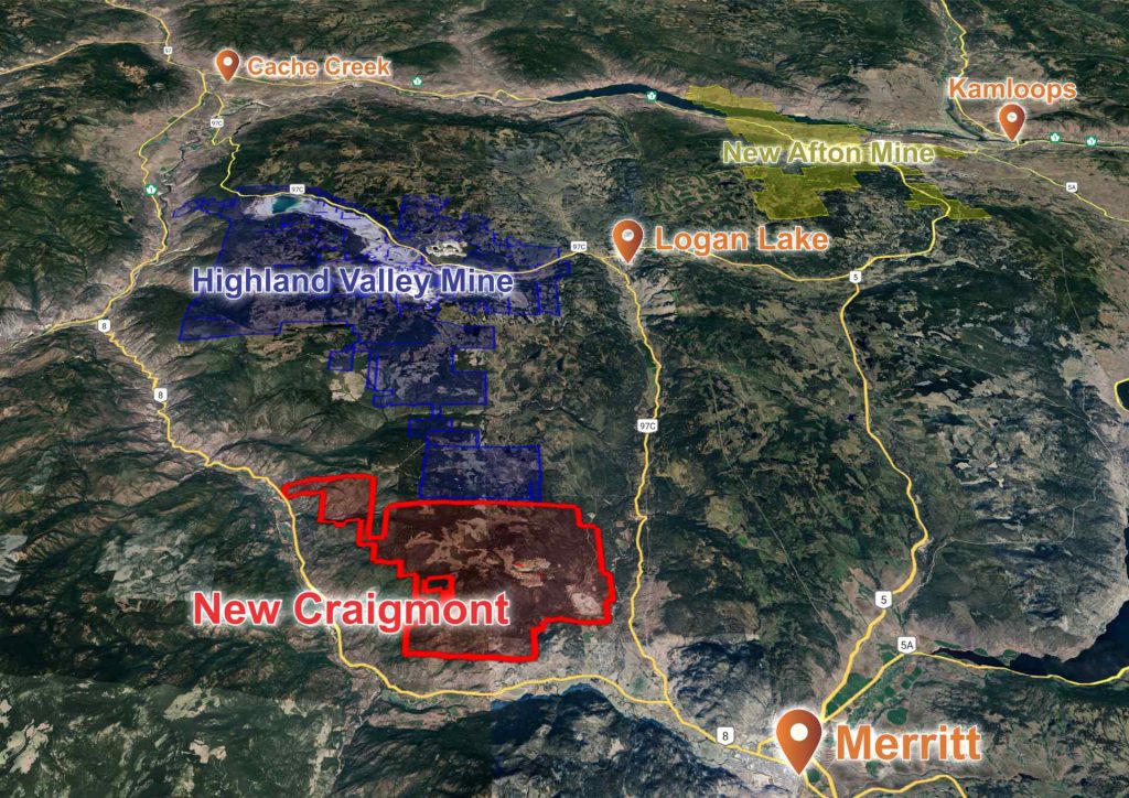
The Craigmont Property is composed of 10 mineral leases and 22 mineral claims covering an area of over 10,800 ha (Fig. 2). Access is by a 14 km paved road from the city of Merritt, British Columbia. The property’s excellent infrastructure, comprising maintained dirt roads, as well as numerous tracks, allows for easy access to all areas of the property. The Merritt Mill is located on the property and benefits from connection to the BC power grid.


The preliminary copper resource for the southern dump and 3060 portal dumps
Bulk preparation and testing of Craigmont samples
Geological Setting
The New Craigmont Property is located on the eastern margin of the prolific Quesnel Trough island-arc terrane, which hosts a significant number of British Columbia’s major copper districts (Fig. 3).
The Upper Triassic volcanic and sedimentary rocks of the Nicola Group are laterally the most extensive group in the Property. These are intruded by Upper Triassic – Lower Jurassic batholiths, of which the Guichon Creek batholith and Iron Mask batholith are the most important from a metallogenic perspective. These batholiths host world-class porphyry deposits, namely Teck’s Highland Valley Copper Operations and New Gold’s New Afton Mine. Lower-Middle Jurassic sedimentary rocks occur more distal to these batholiths. A Late Cretaceous volcanic belt (Spences Bridge Group) predominates the west of the property. This belt is known to contain epithermal-style gold mineralisation. Large N-S trending faults have considerable displacement, the most significant of which are the Guichon Creek Fault and Lornex Fault, which are east and west of the New Craigmont Property, respectively. Deposition of Eocene volcaniclastics (Princeton/Kingsvale Group) is controlled by paleotopography. More recent (Miocene to Holocene) volcanism is generally of little economic interest.

The New Craigmont Property is bound to the east and west by two large faults, the Guichon Creek Fault and Lornex Fault, respectively. Late Cretaceous volcanics (Spences Bridge Group), west of the property, are partially offset along the Lornex Fault. Eocene volcaniclastics (Princeton/Kingsvale Group) overlie the contact between the Guichon Creek batholith and southeast of the property. The historic Craigmont mine partially exploited the copper-magnetite skarn mineralisation located within the contact aureole of the Upper Triassic Guichon Creek batholith with the Upper Triassic Nicola Group volcanics.
The property covers the southern contact of the Guichon Creek batholith and the Nicola Group rocks composing of volcanic clastic rocks and sedimentary rocks (Fig. 4). The Craigmont skarn deposit was hosted by the Nicola Group rocks adjacent to the batholith, which is known to have produced between 33-36 million tonnes of high-grade ore. During the mine’s production it is estimated to have recovered 887.8 million lbs of copper, 3 billion lbs of magnetite and minor amounts of gold and silver.
An additional 14 showings of copper mineralization of both skarn and porphyry-style are located on the property. Review of the historic work has indicated that these showings remain largely underexplored, with limited drilling on four of these showings (Embayment, Eric, Titan Queen and Arh).
Reconnaissance geological mapping conducted in 2016 & 2017 mapped the Guichon Creek batholith around the Titan Queen showing and Nicola Group east of the Betty Lou showing. This was the first broad reconnaissance mapping since mine closure in 1982. The most significant outcome was the identification of the extent of the hydrothermal alteration of the Guichon Creek batholith and the Nicola Group. Extensive follow-up mapping in 2023 produced a detailed geological map of the entire property. This mapping campaign identified new copper showings and identified several key areas for more detailed exploration, namely the CAS-MARB area and the WP/MARB72 area.

Ongoing Exploration
Introduction
Nicola successfully consolidated the ownership of the mineral claims and leases that now form the New Craigmont Project in November 2015. Prior to this, wide-scale exploration was not undertaken to due to multiple owners of the tenures covering the region. Since the consolidation the company has been actively engaged in exploration activities on the project. This extensive effort includes conducting over 18,000 m of diamond drilling, 1,869 m of reverse circulation (RC) drilling and property-wide detailed geological mapping. The company has also carried out widespread soil sampling, along with advanced geophysical surveys including induced polarization (IP), aeromagnetic surveys, and a ZTEM survey across the property (more on these geophysical surveys below). Ongoing exploration is significantly assisted by cashflow from Nicola’s peripheral operations.
Generally, there are two exploration objectives: extending the known skarn mineralization that was historically mined (more on this below), and vectoring for a (or several) porphyry copper system(s), which is believed to be the source of fluid responsible for the skarn mineralization. Geological setting, outcrop and drill core observations, as well as geophysical anomalies support the copper porphyry hypothesis. A collaborative study with the UBC is ongoing to investigate the presence of a porphyry system on the property (more on this below).
Furthermore, Nicola has focused on enhancing copper grades in the historic waste dumps by employing X-Ray Transmission (XRT) sorter technology. Highlighting these efforts, a technical report compliant with the National Instrument 43-101 – Standards of Disclosure for Mineral Projects was published on May 21, 2020. This report, which focuses on the historic mine waste terraces, was subsequently filed under the company’s profile on SEDAR on June 1, 2021, providing a detailed account of the exploration activities and findings. In Summary, 1,869 m of RC drilling on the Southern Dumps and 3060 Portal Dumps was used to develop an inferred mineral resource of 18.7M tonnes at 0.13% copper (see NI-43 101: New Craigmont Project Technical Report). Concurrent to the inferred mineral resource, Nicola evaluated the upgrading potential of copper grades through the utilization of XRT sorter technologies (June 15 2020 news release) and identified the potential economic contribution from magnetite at low grades (February 19 2019 news release).
Drilling Highlights
Below are recent exploration highlights from skarn targets (Craigmont Central, No. 3 Ore Body and Embayment Zone – see photos in core gallery).
- DDH- THU-002: 85.92m @ 1.11% Cu (Embayment Zone)
- S-100: 116.7m grading 0.54% Cu (resampling; Embayment Zone)
- NC-2018-01: 71.4m @ 0.6% Cu (Embayment Zone)
- NC-2018-03: 100.6m @ 1.30% Cu (Embayment Zone)
- CC-18-02: 73.6m @ 1.05 % Cu (Craigmont Central)
- CC-19-72: 34.0m @ 0.40% CuEq and 44.0m @ 0.56% CuEq (No. 3 Ore Body)
MYAB (Exploration) Permit
Nicola has been granted a multi-year area-based exploration Permit (MYAB Permit, MX-4-697, see November 21, 2022 news release), allowing for an extensive range of exploration activities on the New Craigmont Property through to November 2027 (Fig. 5). This permit authorizes Nicola to advance its copper exploration strategy, including the deployment of geophysical surveys utilizing exposed electrodes, the drilling of up to 190 diamond drill holes, and the execution of trenching and bulk sampling across 12 kilometers, impacting an area of 6 hectares.

Collaboration with UBC’s MDRU (Mineral Deposit Research Unit)
On June 29, 2022, the company disclosed its entry into a funding agreement with the University of British Columbia (UBC) and its Mineral Deposit Research Unit (MDRU) to explore the potential and presence of copper porphyry systems. The MDRU represents a collaborative initiative between UBC’s Mineral Deposit Research Unit, Lakehead University, the Universities of Alberta and Calgary, along with 15 partner organizations, including Nicola. This partnership is dedicated to enhancing the efficiency and success rate of discovering porphyry copper deposits, leveraging combined expertise and resources to advance mineral exploration and research in this critical area.

Geophysical Surveys
An advanced suite of geophysical surveys has unlocked significant insights into the mineral potential of the New Craigmont Project. The Magnetization Vector Inversion (MVI) model (Fig. 6) highlights a significant magnetic anomaly in the MARB-CAS zone, mirroring the scale of the historical Craigmont Mine and indicating high mineralization potential. Concurrently, the Z-Axis Tipper Electromagnetic (ZTEM) survey (Fig. 7) has illuminated a sizeable resistivity anomaly in the property’s western region (West Craigmont – WP area), which is a promising target for porphyry exploration.


2023 Exploration
On December 21, 2023, the Company announced completion of the 2023 drilling program at New Craigmont. Nicola drilled six diamond holes totaling 2,684 metres adjacent to the historic Craigmont Copper Mine. The Program aimed to explore the potential of a southeastern extension of the historic Craigmont skarn ore body and to investigate the potential of a porphyry copper system. Highlights of the program were the discovery of extensive potassic alteration, propylitic alternation, discrete zones of copper (chalcopyrite) mineralization with localized molybdenite (see photos in core gallery).
2024 Exploration
The 2024 exploration plans are set to launch a detailed 3D Induced Polarization (IP) survey, as announced on February 21, 2024, targeting the identified anomalies of MARB-CAS and the West Craigmont – WP area. This survey aims to bridge the data gaps from the 2017-2018 IP surveys and refine drill targets, enhancing the precision of exploration strategies based on the integrated geophysical data.
The historic Craigmont Copper Mine, located 14km from Merritt, British Columbia, operated from 1958 to 1982. Over its operational life, the mine produced more than 36,750,000 tons of ore, which had an average grade of 1.30% copper (Cu). This resulted in approximately 900,000,000 pounds of copper being extracted through both open-pit and underground mining activities, collectively known as ‘Craigmont Central’.[1]
[1] “Annual Report 1982”, Craigmont Mines Ltd. (December 1, 1982)
")
")


During the final years of the Craigmont Mine’s operation (1977 to 1979), Craigmont Mines Ltd. undertook a limited exploration program on-site. This program was more focused on a smaller area than the one currently controlled by Nicola. It was based on the conceptual understanding that ore metals originated from the surrounding country rock. These metals were thought to have been mobilized by the heat from the Guichon batholith and subsequently concentrated in skarns formed along reef-margin facies. However, this exploration did not significantly increase the mine’s reserves. The Craigmont Mine ceased operations and was dismantled in 1982, primarily due to low copper prices, which were at $0.60 per pound at the time. Since the early 1980s, the lack of unified ownership has hindered comprehensive mineral exploration efforts on the Craigmont Mine project.
")

Below are the PhD theses of Dr. Norman Bell Keevil of Tech Mining Corp. and Dr. Arthur Darryl Drumond formerly of Placer Dome Mining Corp who were the operators of the Craigmont mine at the time these were written. They form the foundation of our evolving geological interpretations of the property.

